The climate of Maine is well known for its variability and
changeability. Weather patterns are varied from season to season, and
year to year, and are quick to change. Typically, there is a
twice-weekly alternation from fair to cloudy or stormy, together with
abrupt changes in temperature, moisture, sunshine, wind direction,
and wind speed. Mainers jokingly sum it up by saying, "If you don't
like the weather, wait a minute."
The convergence in Maine of three types of air masses accounts for
the frequent abrupt changes in weather: (1) cold dry air pouring down
from subarctic North America, (2) warm, moist air streaming up on a
long overland journey from the Gulf of Mexico and subtropical waters,
and (3) cool, damp air moving in from the North Atlantic. In general,
the first two types of air masses predominate.
Maine has been divided into climatic regions by Lautzenheizer (1972)
and Fobes (1946). Interestingly, both sources define a coastal and
southern interior region, but Fobes places the Merrymeeting Bay area
in the interior while Lautzenheizer includes it in the coastal
division. The two regions differ according to the degree of influence
of the sea breezes which act to moderate extremes in temperatures and
which cause greater humidity and cloudiness or fogginess in the
coastal region. Meteorological data from Augusta and Gardiner at the
northern end of the Bay, and Brunswick to the south, seem to indicate
that the Bay lies in a transition zone between coastal and southern
interior climates. Consequently weather conditions vary substantially
from one end of the Bay to the other, Brunswick being influenced by
coastal climatic conditions, and Gardiner by interior conditions. The
following discussion describes various climatological indicators for
Merrymeeting Bay.
1. Unless noted otherwise, data from Lautzenheizer 1972.
Temperature data have been recorded at stations in Gardiner and
Brunswick and are listed in Table 3-1. Significantly, mean monthly
temperatures show greater variation in Gardiner than in Brunswick,
with winter temperatures lower and summer temperatures higher than
Brunswick whose temperatures are presumably moderated by sea breezes.
Gardiner temperatures have been recorded as high as 105_F in the
summer (Fobes 1946). Portland, a southern coastal town similar to
Brunswick, records 100_F as its highest temperature. For the region
as a whole, the mean maximum temperature (_F in July) ranges from
78_F to 80_F, based on data recorded from 1931-68. Similarly, mean
minimum temperatures (_F in January) range from 10_ to 12_F.
Freeze data collected for Brunswick and Gardiner are shown in Table
3.2. Again, these reflect the climatic differences for the two
regions of the Bay. Spring comes later and winter earlier in
Gardiner, with the result that Brunswick has a growing season an
average of a full month longer. Gardiner has 133 freeze-free days as
compared to Brunswick's 163.
Precipitation is quite evenly distributed throughout the year in
Merrymeeting Bay with no one season having significantly greater
amounts than others (see Table Monthly amounts range from 3.10 inches
to 4.90, and annual totals average 44 to 46 inches). Over the years
the southern portion of the Bay has averaged slightly greater amounts
than the northern portion.
Periods of extended or severe drought are rare in the area. Just
north of the Bay in Augusta, the driest year of record was in 1946
when the annual precipitation recorded was 31.5 inches, 77% of the
long period average. Similarly, the greatest annual amount of
precipitation at that station was 55.6 inches, a 25% increase over
the long term average.
Snowfall occurs in the Bay area from November through April with
minor amounts in October and early May. Yearly totals average 77.8
inches in Brunswick and 81.8 inches in Gardiner with heaviest amounts
during the months of January and February (see Table 3-1 ). Augusta,
to the north of the Bay, has recorded extremes of 106.1 inches in
1955-56, and 29.3 inches in 1952-53.
Wind data for Brunswick are available from the Naval Air Station
(Maine Yankee Atomic Power Co. 1971). These data, recorded from 1952
to 1968, indicate that winds prevail from the north, northeast and
northwest from October through March, and from the south and
southwest from April through September. Calm conditions (O to 3 mph)
have been recorded 14.6 percent of the time. In Augusta, calm was
recorded 18% of the time.
Wind speeds have been recorded immediately east of the Bay in
Wiscasset (Maine Yankee Atomic Power Company 1971). These range from
1 to 40+ miles per hour with highest wind speeds originating from the
northeast. Augusta, to the north, records an annual average velocity
of 8.6 miles per hour and Portland, to the south, an average of 8.8
miles per hour.
The number of clear days per year in the southern half of the
state ranges from 80 to 120 days. Portland, south of Merrymeeting
Bay, records an average count of 108 clear days each year. Fobes
(1946) describes an increase in clear days from coastal to southern
interior climatic zones, and hence it is likely that the Bay,
especially its interior section, has a higher number of clear days;
according to Fobes, this may be as high as 154 days.
Visibility, affected by fog and precipitation, is less than one mile
9% of the time in Augusta, ranging from 12% in spring to 6% in the
fall.
Similar records for the southern part of the Bay are not available,
but due to the closer proximity to sea breezes, it is assumed that
poor visibility conditions will be more frequent in this area.
1. Sky cover is expressed as a range of 0 for no clouds or obscuring
cover to 10 for complete sky cover. A clear day ranks 0 to 3 in sky
cover.
Some of the Bay areas climatic features present possibilities that
have not as yet been fully explained; however, with the nation's
current concern with future energy needs and the adequacy of food
production, the following factors require reconsideration:
1. Since the Bay tends to be influenced by the moderating influence
of coastal climate, it has a particularly longer growing period and
farmers and gardeners stand to gain over similar locations away from
the sea.
2. With possibly 45% clear, cloudless days throughout the year, all
structures and, particularly homes, should be constructed to utilize
the sun for supplemental heating, either by simply facing large
double-glazed windows south or by utilizing solar heating
systems.
3. Likewise, all construction should be very well insulated to cut
heat loss during the coldest periods of the year. The Danish have
built a house that is commercially available in Maine that is so well
insulated that it apparently relies on body heat and heat from light
fixtures as its sole source of heating (see Island Ad-Vantages,
9/27/74).
4. With an average annual wind speed of 8.8 m.p.h., the feasibility
of utilizing wind power as an alternative energy source is realistic.
Maine's only wind generator manufacturer is located in Brunswick.
Because of the favorable climatic conditions in the Bay area,
which include a relatively long growing season with a high number of
cloud-free days and moderate temperatures, evenly distributed
precipitation, infrequence of drought or flood level rains., and good
air circulation, we feel the Bay area could benefit greatly by:
1. Encouraging farm activities, especially in prime agricultural
areas which are described in Chapter 4,0, section 4.4.2.
2. Supporting the development of alternative energy systems
appropriate to the Bay, including wind and solar power.
3. Educating builders and homeowners on how to best utilize the Bay's
favorable climatic conditions through site orientation and
insulation.
TABLE .3-l
MEAN MONTHLY AND ANNUAL CLIMATOLOGICAL INDICATORS

	Temperature ('F)		Precipitation (in.)		Snowfall (in.)
	Brunswick	Gardiner	Brunswick	Gardiner	Brunswick	Gardiner
Jan.	21.7		20.4		3.63		3.81		21.8		22.8
Feb.	26.5		21.5		3.10		3.29		20.2		21.4
Mar.	31.9		30.6		4.04		3.75		14.2		14.5
Apr.	43.2		42.6		3.65		3.96		3.9		4.9
May	51.1		54.1		4.16		3.39		0.3		0.5
June	62.4		63.1		3.53		3.31		--		--
July	68.1		68.7		3.36		3.57		--		--
Aug.	66.6		67.3		3.93		2.90		--		--
Sept.	59.5		59.0		3.28		3.77		--		--
Oct.	49.2		48.9		3.69		3.79		Trace		Trace
Nov.	39.5		37.9		4.90		4.59		4.8		5.4
Dec.	27.0		24.7		4.15		3.82		12.6		12.3
Annual	45.5		44.9		45.42		43.95		77.8		81.8

SOURCE: SCS 1974.
% Chance of			SPRING DATE			FALL DATE
Freezing (32 F.)	Brunswick	Gardiner	Brunswick	Gardiner

90%			April 18	May 2		Oct 26		Oct 10
50%			May 2		May 16		Oct 19		Sept 26
25%			May 9		May 23		Oct 5		Sept 19
10%			May 16		May 30		Sept 28		Sept 12

SOURCE: Lautzenheizer 1972. 1
Merrymeeting Bay lies in a region known by geographers as the
"coastal lowlands," one of Maine's three distinct physiographic
provinces (Fenneman 1938). The topography
of this region is almost flat to gently rolling, and slopes
toward the sea. The average altitude of the region is about 100 feet
above sea level.
MISSING TEXT FROM PAGE 3-8
Slopes are significant in that their degree of steepness influences
the susceptibility of an area to erosion. This study has defined the
following ranges:
Sediment yield from any disturbance of the landscape is directly
related to the degree of slope and the length of slope. Various
studies have concluded that slopes greater than 25% pose severe
problems in the control of erosion and sedimentation from normal
construction practices and that all types of development be excluded
from these areas (Leopold 1972). In fact, slopes ranging from 15 to
25% are also considered highly vulnerable and costly to develop, and
depending on the location, extent, and soil type associated with
these areas, these might also require protection.
The length of slope is less critical in determining erosion
susceptibility than is the degree of slope. One study showed that
increased slope from 5 to 10 percent increased erosion by 230
percent, while doubling the length of the slope increased it by only
22 percent (Musgrave 1947).
The geology of Merrymeeting Bay and its adjacent lands is
complex,reflecting a long history of geologic processes including the
advance and recession of the ocean, mountain building and volcanism,
erosion, sedimentation, and glaciation. Generally the first 450
million years saw the development of processes which formed the
present bedrock units. Processes occurring in the last one million
years shaped the current surficial geology and soils characteristics.
These will be discussed in detail below.
The bedrock units were formed by a series of events, beginning
with the deposition of sediment and volcanic material in ocean basins
during Ordovician times, about 450 million years ago. Subsequent
compacting and cementation lithified the sediments; in the
Merrymeeting Bay area, clay became shale and sand became
sandstone.
Following these events about 400 million years ago, the earth's crust
began to fold and uplift, and the submarine units were raised above
the sea forming high mountains. This process, lasting some 120
million years, also metamorphosed the geologic units as it lifted and
folded them. Much of the sandstone was converted to quartzite, and
the shale became slate, phyllite, schist, and gneiss.
Subsequent periods of erosion (until 1 or 2 million years ago)
andglaciation (within last million years) with intermittent uplifting
anddepression of land surface altered the bedrock geology of the
region only insignificantly. These periods did, however, shape the
surficial geology and soil characteristics now found in the Bay.
The surficial geology of the area can be viewed as the product of
processes which began in the last 1 to 2.5 million years. This
period, known as the Pleistocene epoch, saw the land transformed by
glaciation. Four major ice advances have been recorded in North
America since the beginning of this epoch., but it is believed that
Maine may have been affected by only the last (Leavitt and Perkins
1935). During that advance the entire state was covered by over 1,000
feet of ice. Merrymeeting Bay, as the rest of the Maine coast, lay
beneath over a mile of the ice.
The advance and retreat of the glacier had many effects on the land.
Moving slowly towards the south, the glacier scoured off tops of
hills, picked up loose soil and rock, and redeposited these
substantial distances from their place of origin. Some of the
material was deposited directly from the ice as till, an unstratified
mixture of sand, gravel, clay, and rock. Till is common in the
Merrymeeting Bay area; it is exposed in the upland areas and
underlies more recent deposits in much of the lowland areas. In
thickness, it appears to range from 2 to 50 feet in depth, and is
underlain by bedrock (estimated from well records and data in
Prescott, 1967,1968a, 1968b, 1969).
As the glacier melted back, streams formed by the melt water picked
up, transported, and deposited more of the debris. Sediments
deposited by this action were well sorted and layered, and formed
distinctive landforms including kames (irregular hills of sand and
gravel), kame terraces, deltas, and outwash plains. These are mapped
generally as ice-contact deposits and glacial outwash.
Some preglacial drainage ways were blocked by glacial debris, and
post-glacial streams had to find new routes (Prescott 1963). The
Androscoggin River is an example of this. Prior to the glacier, it
probably did not flow between Brunswick and Topsham, over solid rock,
as it does now. Most likely, it followed a more direct route to the
sea through a channel buried by glacial deposits.
The weight of the glacier had the effect of depressing the land
surface several hundred feet. This, combined with the rising of the
ocean from glacial meltwaters, resulted in the submergence of the
Merrymeeting Bay area for a period of time until the land began to
uplift or rebound after its release from the weight of the glacier.
While submerged, fine grained materials, now known as marine clay or
marine deposits, settled in the lower basins. These can now be found
as much as 300 feet above sea level. Since glaciers, streams have
deposited sediments, called alluvium, over the glacial and marine
deposits; peat and muck have formed in swamps and marshes (known as
swamp deposits); and wind action.has deposited finegrained silt and
sand in discontinuous patches over the glacial deposits.
Planning Implications
For planning purposes, bedrock geology is useful for the following
reasons:
1. It shows the presence or absence of fault zones which could be
unstable and hazardous to developments. In our study area, there are
no such zones.
2. It shows areas which have low compressive strength and which
could, then, be hazardous as foundations for construction. Again, in
the Merrymeeting Bay area, this is not a problem
3. It could point out units which could be potential
aquifers--formations capable of storing and transmitting sizable
quantities of water.Cavernous limestone and volcanic rock (basalt)
are examples of this. In our area, bedrock units are not particularly
suited as aquifers.
The importance of surficial geologic information lies mainly in what
it reveals to us about the groundwater characteristics.
Unconsolidated geologic units are the primary aquifers in any region.
The best units for bearing water are ice contact deposits and glacial
outwash. Most of the other deposits yield only very small quantities
of water. The following section, 3.4 Hydrology, describes the
groundwater conditions and opportunities in the area in detail.
Detailed soil mapping and analysis have been completed for
SagadahocCounty by the U.S.D.A. Soil Conservation Service (1970) as
well as for Cumberland County (1970) and Lincoln County
(unpublished). The soils of Merrymeeting Bay are very complex. Parent
materials are generally glacial in nature: glacial till, lacustrine
sediments, and glaciofluvial materials, though large areas of
alluvial deposits are located in the low-lying plains bordering the
Bay and rivers (see Table 3-3 for a description of these). Till and
lacustrine sediments are about equally distributed over the higher
ground. The tills were derived mostly from schist but contain varying
amounts of material weathered from granite and gneiss. The
lacustrinesediments were derived from schist, granite, sandstone, and
shale and are distinctly stratified. Glaciofluvial materials,
deposited as outwash from the glacier, are composed of sorted sands
and gravel. Recent alluvial deposits were derived from material
washed from the glacial soils and deposited along streams. Organic
soils, such as peat and muck, are uncommon in the Merrymeeting Bay
area.
This study has examined soils for their suitability for two uses:
(1) on-site sewage disposal and (2) agricultural uses.
On-Site Sewage Disposal
In determining areas suitable for on-site sewage disposal, guidelines
were used from the State of Maine Plumbing Code, July 1974, issued by
the Department of Human Services. Four categories of suitability were
applied from the Code:
1. permitted
2. permitted with a minimum lot size requirement of 40,000 square
feet (approximately 1 acre) due to presence of groundwater recharge
areas (highly permeable soils overlying principal aquifers.
3. permitted with a minimum lot size requirement of 80,000 square
feet (approximately 2 acres) due to permeable soils within 30 inches
of the groundwater table.4. not permitted or not economically
feasible.
Soils classified as unsuitable (type 4) are found primarily in low
wet areas adjacent to streams--a large expanse in the upper Cathance
River in Topsham; most of the Muddy River drainage; lowlands
comprised of alluvial soils along the lower Abagadasset River
(including the Beach Point-Centers Point-Bald Head area; and the
Abagadasset Point lowlands); and various other areas adjacent to the
lower Androscoggin River, the east bank of the Upper Kennebec River,
and much of the Green Point area along the Eastern River. Soils
requiring minimum lot sizes of 1 to 2 acres are found predominantly
in the southern part of Topsham and in Brunswick along the
Androscoggin River. The Management Area Plans found in Chapter 8.0
take into account these areas.
Agricultural Uses
Soil Conservation Service criteria for agricultural suitability were
used in determining prime agricultural soils in the Merrymeeting Bay
study area. Three general categories were identified:
(1) Class I Soils: slight or no limitations to agricultural uses
(2) Class II Soils: moderate limitations
(3) Classes III-VIII Soils: severe to very severe limitations
Class I soils are rare in Maine as they are in the United States as a
whole (only 2% of the total land area in the United States is so
classified). In the Merrymeeting Bay area, however, large acreages
are found from Pork Point to Centers Point and along the lower Muddy
River to the west of the Bay. Class II soils are scattered throughout
the study area but are especially numerous west of Richmond, adjacent
to Class 1 soils from Pork Point to Centers Point, and on Green Point
in Dresden. The importance of these soils is reflected in the
Management Area Plans detailed in Chapter 8.0 and discussed further
in section 3.5.
Planning Implications
Soil characteristics are a significant factor for determining
thesuitability of an area for a number of activities. This study has
focused on residential development with on-site waste disposal and
agriculture. Because of the nature of the soil survey which details
an area according to its dominant soil, exceptions to interpretations
are likely to occur based on on-site inspection. Nevertheless, soil
characteristics as described by the surveys can be used to indicate
generally areas most suited to residential development and most
valuable as farmland despite the fact that exceptions may occur.
The methodology used to determine suitability for on-site sewage
disposal in this study departs from the traditional use of
SCS-prepared interpretations. By using the State Plumbing Code
guidelines, it is felt that a more realistic analysis has resulted.
The technology for treating wastes in areas once determined as
unsuitable has improved and this is reflected in the Plumbing Code.
As a result, fewer areas are classified as unsuitable. It is likely
that this trend towards the development of systems able to overcome
site limitations will continue and that, in time, the major
limitation will be cost.
What this implies is that towns must realize that soil limitations
nolonger can be used as the basis for guiding growth. Other
considerations must be developed as the rationale for maintaining the
present Bay character.
As to the agricultural suitability analysis, this too has its
limitations. What it depicts are the areas most suited to large scale
commercial farming. Again, that Class III soils have severe
limitations to agricultural uses does not imply that they are
unsuited. It simply means that additional cost and effort will be
required to make them as productive as Class II or Class I soils.
With the trend towards small scale organic farming in the area (SCS,
Time and Tide Resources Conservation and Development Project), there
is reason to believe that these might also have enough value to
warrant special attention in town planning efforts. A town could, for
example, decide that enough land will be retained as agricultural in
its bounds to provide 1/3 or 1/2 of the food requirements of the
town, regardless of the area in prime agricultural soils. Connecticut
has set an example in this respect at the state level (Cowley
1975).
Merrymeeting Bay is a large fresh water hay formed by the
confluence of six rivers including Maine's second and third largest,
the Kennebec, which drains 5,870 square miles, and the Androscoggin,
draining 3,450 square miles (Maine State Planning Office 1974). Other
minor rivers which flow into the Bay include the Eastern, Cathance,
Abagadasset, and Muddy Rivers, draining collectively less than 200
square miles.
The Bay itself measures approximately fifteen miles in length, and
varies from one-half to three miles in width. In area, it occupies
from 8400-9600 acres. Depths vary from two to sixteen feet in the
main body of the Bay to 71 and 98 feet at the Chops Narrows.
Tidal influence extends as far as Augusta on the Kennebec, to the
dams in Brunswick on the Androscoggin, the length of the Eastern
River, the Cathance Road on the Cathance River (mill dam), one mile
south of Baker Brook on the Abagadasset River, and the full length of
the Muddy River. Salt water influence ceases at a point just below
the Chops Narrows.
As mentioned previously in section 3.1, Merrymeeting Bay receives a
mean annual precipitation of 44 inches of which about half flows
underground and overland to surface water bodies as runoff. The other
half is directly evaporated or utilized by vegetation and then
evaporated or "transpired."
Runoff is the component of the hydrologic cycle which results in
variations in streamflows. Logically, a year which records an
unusually high amount of precipitation will also record unusually
high streamflows. For instance, runoff for the water year 1973
(October 1972 to September 1973) was excessive averaging 70% higher
than the previous year in southern Maine, including Merrymeeting Bay
(U. S. Geological Survey 1973). This corresponded to unusually high
precipitation levels, as much as 12 inches above normal. As a result,
the Androscoggin River at Auburn, Maine, which has averaged an annual
flow of 6,032 cubic feet per second (cfs) over a 45-year period of
time, rose to 8,305 cfs in 1973 with a maximum flow of 45,800 cfs in
July, and a minimum of 552 cfs in October (U. S. Geological Survey
1973). This large fluctuation is partly accounted for by the
regulation of flows through numerous impoundments upstream for
industrial use and hydroelectric power, but the magnitude of the
increase is a direct function of runoff.
A number of factors besides precipitation levels influence the amount
of runoff for a given area. These include soil porosity, the amount
of water already in the soil (% saturation), the slope of the ground,
the amount and type of vegetative cover, the intensity of the
rainfall, and the position of the water table (a high water table
forces more water to runoff over land). Many combinations of these
factors could act to produce excessive runoff levels, especially when
combined with high precipitation levels.
Flooding occurs when the flow of a river overreaches its established
channel. In Merrymeeting Bay, this can result from runoff in the
headwater regions of the Kennebec and Androscoggin Rivers, or from
coastal storms which raise the normal tide level. The record level of
tidal flooding occurred in 1945, when the tidewaters rose to levels
two feet above the annual high spring tide stage. The flood of record
caused by conditions in the upstream regions occurred in 1936. At
that time, the Androscoggin River at Auburn registered a flow of
135,000 cfs as compared to its normal flow of 6,032 cfs (U.S,G.S.
1973).
Mapping of flood-prone areas in the
project study area has recently been completed by the U. S.
Geological Survey and the federal Department of Housing and Urban
Development in response to the federal Flood Insurance Act. The areas
delineated represent estimations of the 100-year flood zone (that is,
the area affected by a flood of such magnitude that it would occur on
an average of once in one hundred years). This work should be
supplanted in future years by work based on field studies.
Groundwater studies have been completed for most of the study area
by the U. S. Geological Survey (Prescott 1968b, 1969). Currently, the
Maine Bureau of Geology is conducting additional surficial geologic
and groundwater studies in the area which will be published sometime
in 1975.
There is relatively little specific information about groundwater in
the Merrymeeting Bay area. Records of well drillings and selected
test holes provide some information, however (Prescott 1967, 1968a).
From water levels recorded in these wells, it can be inferred that
groundwater basins correspond to surface water drainage basins, and
that the water table generally slopes toward the streams, discharging
into them except during periods of exceptionally high streamflow when
the reverse would occur. This relationship is termed "influent" when
the groundwater flows or discharges into the surface water. The depth
to the water table varies throughout the study area from O to 34
feet, but is most commonly found from 5 to 15 feet (based on records
from dug wells in Prescott 1967, 1968a).
The most common aquifers (a geologic unit capable of storing
andtransmitting large quantities of water) in the area are
unconsolidateddeposits, either till, outwash, or ice contact
deposits. Some limited amounts of water are available from bedrock
aquifers as well. Table 3-3 describes the major aquifers in the area
in terms of yield and quality. Areas particularly favorable as water
supplies are found in the following areas: (1) outwash deposits north
of Topsham Airfield and around the Topsham I-95 interchange, (2)
alluvium and outwash deposits underlying Brunswick and adjacent to
the Androscoggin River from the railroad crossing to the area
adjacent to Mustard Island and south, (3) an area north of the
Androscoggin between Foreside Road and Route 24, (4) ice contact
deposits near Wheeler Hill along both branches of the Cathance River,
(5) ice contact deposits on the east bank of the Kennebec just north
of Swan Island, and (6) alluvial deposits on the east bank of the
Kennebec opposite Richmond Campground to the Kennebec County; Lincoln
County line (Prescott 1968b, 1969).
		Character				Water-bearing Characteristics

Alluvium	Sand, silt, and clay, with some		Deposits are generally thin, fine
		gravel, of river flood plains		grained and subject to inundation
		and fluviatile terraces. In		by flooding, and are not considered
		valleys of small stueams may		a significant aquifer. In Dresden
		occuu as small discontinuous 		and Bowdoinham includes a few
		patches adjacent to channels		but broad areas of fluviatile sand,
		in places along the'Kennebec		which yields water to a few wells,
		River between Shawmut and Rich- 		but does not constitute a major
		mond forms a mappable unit.		aquifer because it is relatively
							thin and fine grained.

Swamp		Partly decomposed organic matter-	Yields water to some spring and dug
Deposits	leaves, moss, rushes, heath		wells. May contain a considerable
		plants, and grass-and some inter-	amount of water, which may be
		mixed silt, clay, and sand.		released slowly to underlying deposits
							or to streams flowing through or
							issuing from them. Contained water
							is likely to be acidic, highly
							colored, or high in nitrate or
							other organic matter.

Eolian		Fine to medium sand and silt.		A source of small quantities of water
Deposits	Generally occurs as fixed,		to a few dug or driven wells. Fine-
		vegetated sand dunes, but also		ness of grain size and generally high
		includes some areas of active		topographic position preclude obtain-
		dunes. Includes some patches		ing large yields from this unit.
		of wind-deposited silt (loess).

Outwash		Stratified sand and some gravel		Outwash yields small quantities of
		in outwash plains. May over-		water to dug or driven wells. In
		lie or interfinger with marine		a few areas properly constructed
		deposits.				and developed wells might yield 50
							to 100 gpm (gallons per minute),
							but generally yields of this magni-
							tude are precluded by the fineness
							of grain size and lack of sufficient
 							thickness of material. Water is
							generally of good quality.

Marine		Dark-blue to gray silt, clay,		Yields small quantities of water to
Deposits	and fine to trery fine sand.		dug wells and springs.
		Tan-colored where weathered.
		Contains layers of sand and
		gravel, a few inches to a few
		feet in thickness.

Ice Contact	Well-stratified to poorly		The source of the largest supplies
Deposits	stratified deposits of sand,		of groundwater in the lower
		gravel, and cobbles, with some		Kennebec Basin. Under most favorable
		silt, clay, and boulders. 		conditions-where deposits are
							coarse grained, have a large
							saturated thickness, and are in
							hydralic continuity with a body
							of surface water for induced
							recharge-yields of more than 1,000
							gpm can be obtained. Water is of
							good quality though locally con-
							tains excessive iron.

Till		A heterogeneous mixture of 		Till is widespread and is the source
		clay, silt, sand, gravel,			of water to many dug wells and
		cobbles, and boulders. Some		springs and some drilled wells.
		deposits are sandy or gravelly		Sustained yield of most dug wells
		and resemble ice-contact depo-		is less than 1 gpm. Dug wells are
		sits except for lack of strati-		likely to go dry in the summer. One
		fication. Other deposits are		drilled well in till is reported to
		rich in clay and very dense		yield 25 gpm. Water is generally
		or are very bouldeny. In some		of good quality except that dug
		exposures the upper few feet		wells are subject to contamination.
		appears to have been washed
		by water.

Bedrock		Igneous and metamorphic rocks		The bedrock formations are dense and
		including granite, pegmatite,		impermeable and contain little
		gneiss, schist, slate, and		water compared to their total volume.
		phyllite.				They contain recoverable water only
							in secondary openings such as
							cleavage or bedding planes, fractures,
							or solution openings. Based on
							present knowledge it is virtually
							impossible to predict aacurately the
							depths at which water-bearing zones
							will be found and how much water will
							be available.to wells. The water
							in bedrock is generally confined
							under artesian conditions--that is,
							the water will rise in a well to a
							level above that at which it is
							reached by the drill. Several wells
							for which information is available
							flowed at the land surface when
							drilled. Water is of good chemical
							quality but is moderately hard.

SOURCE: Prescott, Glenn C., Jr. 1969. HA-337. U.S.G.S., Augusta.
Presently, several towns in the Merrymeeting Bay area utilize
groundwater for public water supply. The largest users are Topsham
and Brunswick serving approximately 3,600 customers, both commercial/
industrial and households, with nearly 650 million gallons per year
(Brunswick and Topsham Water District, personal communication 1975).
Current capacity is about three times that amount. This water
district depends solely on groundwater or public supplies as do
Bowdoinham and Richmond. In 1973, Bowdoinham served 147 customers
with an estimated 12 to 15 million gallons of groundwater (U. S. G.
S., personal communication 1975).
Natural recharge of aquifers occurs from infiltration of
precipitation. One study estimated that this would amount to an
annual recharge in Maine ranging from 180 to 360 million gallons per
square mile (Erinakes and Smith 1968). Many factors such as
permeability of soil cover and surficial geology, slope, type and
amount of vegetative cover, and intensity of rainfall influence the
amount of water transmitted to groundwater aquifers as recharge. One
of the most important of these factors is permeability of soil and
surficial geologic units. In the Merrymeeting Bay area, the most
permeable areas and hence those most critical for maintaining
continued groundwater supplies are ice contact deposits and glacial
outwash. These are capable of recharging groundwater at ratesranging
from 400 to 1000 gallons per day per square foot. Swamp deposits are
water saturated and are generally discharge areas, or areas where
groundwater flows toward the surface.
Knowledge of groundwater characteristics is critical for sound
resource based planning for the following reasons:1. Currently all
municipal water supplies in the Merrymeeting Bay area are obtained
from groundwater resources. Identifying and locating the principal
aquifers is important, therefore, as development should be placed in
close proximity to these to avoid unnecessary costs for water
supply.
2. Identifying and locating aquifer recharge areas is important for
the maintenance of adequate groundwater supplies. Therefore,
development should be carefully placed in areas that will not
contaminate existing or potential municipal supplies. Secondly, these
areas should be protected against alterations which would drastically
reduce their recharge capability. This means primarily a control on
the density of development. Table 3-4 illustrates the relationship
between development density andloss of recharge capability.
Lot Size			% Reduction of
Square Feet	Acres		Permeable Area
 6,000		1/7		80
15,000		1/3		25
75,000		1.8		8

SOURCE: Leopold 1972.
3. The effects of reducing aquifer recharge areas include, in
addition to lowering groundwater levels, the increase in surface
runoff and hence increases in flood peaks during storm periods.
During dry periods there will be less groundwater available to
streams and low flows will be accentuated.
The study of surface water hydrology is significant for planning
purposes for the following reasons:
1. Drainage areas are a significant factor in estimating
sedimentcontribution to the Bay. Sediment yield per square mile
decreases with increasing drainage area (Leopold 1972). As a result,
particular attention should be paid to activities in the small
drainage areas around the Bay.
2. The character of the drainage basins is also an important factor
in sediment production. Unurbanized basins yield from 200 to 500 tons
of sediment per square mile per year; while urbanized or developing
watersheds yield from 1,000 to more than 100,000 tons per square mile
per year (Wolman 1964).
3. The flow characteristics of the surface waters also affect
sediment contribution. Most sediment is transported in periods of
peak flow. If a stream or river is subject to flash flooding or
frequent high flows, sediment contributions to the Bay will be
substantial. Activities which accentuate peak flow intensities and
occurrences include the removal ofvegetation and the reduction of
permeable areas, both of which are a by-product of development.
For example, if an area is developed such that 20 percent of its area
is made impervious, studies have shown that the average annual flood
will increase by a factor of 1.5. If an area is 50 percent
impervious, the flood frequency will be quadrupled (Leopold
1972).
4. Floodplains play an important role in regulating the hydrologic
regime during storm periods, They act to settle out sediments, store
excess waters, and release them slowly over time to the stream
channels. Development in the flood prone areas will increase flood
frequency and flood levels, as well as result in high social costs
for flood damages.
An ecosystem can be defined as a community of organisms
interactingwith their inanimate environment; or a system resulting
from theintegration of all living and non-living factors in the
environment (Van Dyne 1969). This study has identified the following
ecosystems for Merrymeeting Bay:
The most important ecosystems in the Merrymeeting Bay area include
the Bay itself and its tributaries, wetlands (tidal flats, marshes,
bogs, wet meadows, and swamps) and forests. Farmland, reverting
fields, suburban areas, and areas of man-induced stress have
important effects on the Bay but are not considered of importance in
the maintenance of the Bay's vital natural functions.
The following discussion will describe in detail the significance of
each of the above ecosystems.
Several ecological studies have been conducted in the Merrymeeting
Bay region. H. E. Spencer (1957, 1959, 1960, 1963, 1966, 1967) did an
extensive ecological investigation of the Bay for the Maine
Department of Inland Fisheries and Game. Other reports have
documented the value of Merrymeeting Bay as a wildlife habitat
(Anderson and Pauell 1961; DeGarmo 1962), and the fishery potential
of the watershed (DeRoche 1967; Foye, et al. 1969; Dow and Flagg,
1970, Flagg 1972).
Overall the Bay is an excellent habitat for waterfowl and is
wellpopulated during spring and fall migration with black duck,
green-winged teal, blue-winged teal, mallards, goldeneye, Canada
geese, and other species. Merrymeeting Bay has the state's largest
spring concentration of geese.
The Bay and its tributaries also provide habitat for a substantial
smelt, alewife, and striped bass fishery which provide good sport and
commercial fishing. The Kennebec River drainage contributes 58% of
the total winter anadromous smelt fishery in Maine (Flagg 1972; see
also Chapter 5.0). Also, the lower Kennebec-Sheepscot River complex
supports the only known populations of shortnose sturgeon in Maine.
The shortnose sturgeon is a rare and endangered species (LaBastille
1973).
In addition, the Kennebec, the dominant system in the Merrymeeting
area, once supported very large runs of anadromous fish (Foye et al.
1969). Historically, development of dams and pollution of the river
have restricted fish movements and destroyed most spawning grounds
for salmon. Consequently, natural anadromous fish runs have been
greatly reduced and much of the Kennebec's anadromous fishery no
longer exists, although remnant runs of salmon, alewives, shad, and
striped bass still take place up the Kennebec as far as Augusta.
The extensive spawning and nursery areas which exist in Merrymeeting
Bay are of limited value to anadromous fishery resources because of
heavy industrial pollution from up-river sources. There is great
potential for an expanded fishery for migrating anadromous fish,
however. Good fishery management in the Kennebec would be most
beneficial for the anadromous fishery of Merrymeeting Bay and the
lower Kennebec. Excellent potential does exist in the upper part of
the drainage. 111e existing potential for Atlantic Salmon has been
estimated at 296 to 2,584 adult fish annually with a potential salmon
nursery area totaling 13,722,550 square yards (Foye et al. 1969). Dow
and Flagg (1970) estimate that fish passage in the main river and all
tributaries below Wyman Dam in Bingham could produce 16 million
pounds per year of alewives. Potential smelt fishery for the Kennebec
below Waterville would be about 500,000 to 1,000,000 pounds per year
if the Augusta dam were removed (Flagg, personal communication).
Expansion of the Kennebec anadromous fishery is dependent on a much
higher water quality in the river. An estimated 500,000-pound
commercial fishery for shad is possible in the Merrymeeting Bay area
alone if water quality can be upgraded to the pre-World War I level
(Philip Goggins, Department of Marine Resources, written
communication, June 1975). To restore the Kennebec drainage to its
full potential for anadromous fish would also require an extensive
and extremely costly fishway construction program according to Fred
Hurley (Department of Inland Fisheries and Game, personal
communication, June 1975).
In consideration of extending the anadromous fishery in the Kennebec
drainage, European carp are an important factor. Carp in Maine are
currently restricted to the lower Kennebec area. The distribution of
this hearty nuisance species has been limited thus far by the absence
of fishways in the Kennebec drainage.
One scheme which would have allowed anadromous fish access to the
upper reaches of the Kennebec was suggested by Flagg (personal
communication 1973). He had proposed that the Augusta dam be removed
to allow fish free access upstream to Waterville. This would have
provided maximum development of the smelt fishery in the 20-mile
stretch from Augusta to Waterville. Other anadromous fish would have
benefited also. A spawning population of striped bass could have been
reestablished in the lower Kennebec River and extension of spawning
areas could have been realized for shad, smelt, and sturgeon. Salmon
angling areas would have become established and, with a man-operated
fishway at Waterville, alewives and shad could have been selectively
allowed upstream further. This was felt feasible as alewives and shad
usually have a four to six week run. As to the carp, pond outlet
streams that enter the stretch between Augusta and Waterville are
obstructed by dams so the problem of carp spreading to new areas
would have been minimized.
Unfortunately, the recent reconstruction of the Augusta dam has
precluded this option for the immediate future. The potential for
restoring the Kennebec to its original status as one of the most
productive fish rivers of the east remains, however, for future times
when the dams have outlived their utility and extensive upgrading of
water quality is realized. are listed in the Appendix. Salinity was
found not to be a limiting factor of the vegetation of Merrymeeting
Bay above The Chops (Spencer 1960). Salt content ranged from 2.0 to
3.5 ppth (10% that of seawater).
Marshes and wet meadows are wetlands in which the dominant
vegetation is emergent non-woody plants. Marshes are a successional
stage in the chronological transition from lakes and rivers to
forests; these transitions are called ecotones.
Because water provides them a fairly stable environment without
eliminating light, marshes are very productive. The productivity of
marshes benefits adjacent water bodies especially. The marshes of
Merrymeeting Bay are subject to tidal fluctuation and are thus highly
productive. Normally, anaerobic sediments limit the availability of
nutrients and, hence, productivity; but here, sediments are aerated
during low tide increasing nutrient availability. There are few other
important stresses acting upon them.
The freshwater marshes are most significant to this study because of
their cover value for waterfowl nesting and rearing. Most of the
important marsh acreage is located in the Muddy and Cathance Rivers.
The major limiting factors in marshes are moisture and substrate. The
wetter areas generally support sedges (Carex spp.), burreed
(Sparganium sp.), manna grass (Glyceria sp.), and some cattail (Typha
latifolia) (DeGarmo 1962). In the drier areas, many grasses,
especially Bluejoint (Calamagrostis canadensis) with associated
Spiraea and blackberry (Rubus spp.) are characteristic.
Swamps are wetlands dominated by woody vegetation and generally
represent the last stage in the succession from lake to forest. Three
types of swamp are found in the Merrymeeting Bay area...coniferous,
deciduous, and mixed. Alder swamps (mixed) occur only along the
rivers; they are prevented from succeeding to forests by high water
each spring.
Transition zones between marsh and upland ecosystems are common.
These generally support dense arboreal growths of alder (Alnus
rugosa), willow (Salix spp.), red maple (Acer rubrum), or ash
(Fraxinus). There are some swampy stands of spruce, fir, and tamarack
present in the Merrymeeting Bay area.
As already mentioned, a great number of different waterfowl
species inhabit the Bay at different times of the year.
Quantities of excellent forage are available for migrating waterfowl
in both spring and fall.
In addition to forage, the surrounding wetlands provide good breeding
cover. Several species (black ducks, ring-necked ducks, blue- and
green-winged teal, mergansers) nest on dry elevated areas either in
the marsh or adjacent upland, usually within 75 yards of the water
(Spencer 1963). In addition, other water bird species are known to
nest in these areas, for example, common snipe, green and great blue
heron, American bittern, pied-billed grebe, greater and lesser
yellowlegs, herring gull, and great black-backed gull (DeGarmo 1962).
A list of most of the birds observed in the area and their status is
included in the Appendix.
Recently, the Inland Fisheries and Game Department has conducted a
survey of inland wetlands in Maine and evaluated them as waterfowl
habitat. Table 3-5 details the wetlands ranked as high to moderate
according to this system in Merrymeeting Bay. Map
No. 7 shows the locations of these and the areas of potential
value (such areas lack standing water presently).
In addition to providing habitat for waterfowl, the variety of
vegetative associations in marshes and swamps also provide excellent
habitat for beaver, otter, muskrat, and other animal species.
Aside from their wildlife values, these wetlands perform a variety of
other functions which help maintain the Bay. These include:
1. Provision of an absorptive capacity for storm water runoff which
minimizes erosion and flood water damage. One acre of marsh is
capable of absorbing 300,000 gallons of excess water. 2. Filtering
and settling out of silt and organic debris from storm waters, thus
helping to prevent the rapid siltation of the Bay. 3. The chemical
and biological oxidation of organics and pollutants. 4. Provision of
recreational and educational opportunities.
Some interesting attempts have been made to attach monetary values to
these functions. Three researchers at the University of Georgia,
Gosselink, Pope, and Odum (no date), value tidal marshes at $4,000
per acre. Another researcher at Georgia State University, Charles
Wharton (1970) calculated that a river swamp is worth:
$1,750/acre/year for education 1,000/acre/year for silt deposition on
agricultural lands 450/acre/year for water quality and erosion
control 250/acre/year for hardwood production 100/acre/year for water
supply giving a total of $3,550/acre/year. This estimate does not
include values attributable to wetlands for wildlife habitat
(hunting, wildlife observation, etc.). Although these figures were
derived in areas outside of Maine, they illustrate generally how
valuable these wetlands are and why it is so important to protect
them.
Forested land in Merrymeeting Bay is divided into deciduous,
coniferous, and mixed forest types, and further into those which have
been recently harvested.
Recently harvested forests are defined as those in which the main
crown canopy is less than half closed or in which the main crown
canopy is less than 15 feet above the ground. Many of these forests,
those which have not been severely damaged, are quite productive.
Their open canopy makes them somewhat inefficient but the vigor of
young growth and the development of undergrowth partially compensates
for it. Disturbed forests often resemble early successional stages
and, like these are not very fragile.
Deciduous forests are those in which hardwoods comprise over
two-thirds of the main crown canopy. An exception may be tamarack, a
deciduous conifer. The height and stratification of forests make them
very efficient users of their environment and deciduous forests are
usually even more productive (net primary productivity) than
coniferous forests (Ovington 1965). This productivity does not apply
to commercial exploitation.
Beech and aspen do provide useable wood but they are marginal species
(economically) compared to most conifers. White Birch is a valuable
resource which in some areas of the state is being overcut due to its
desirability (Fred Holt, Bureau of Forestry, written communication,
June 1975).
Because they are a climax or subclimax ecosystem, forests are more
complex than other ecosystems. This complexity provides some
stability, but because the ecosystem is so highly evolved, it takes
much longer to recover from a serious disturbance.
Coniferous forests are those in which softwoods or evergreens
comprise over two-thirds of the main crown canopy. These forests are
presently more valuable than deciduous forests from a commercial
standpoint because they are in greater economic demand. However,
there is a growing demand for hardwood for veneer, boat stock lobster
trap stock, etc. (see Chapter 4, section 4.4.2, for a discussion of
their economic significance in Merrymeeting Bay). The density of most
coniferous canopies limits the growth of herbs and shrubs and the
relative unpalatability of conifers limits animal production. Like
deciduous forests, coniferous forests are slow to recover from
serious disturbances due to their highly complex nature.
Mixed forests are those in which neither conifers or deciduous trees
comprise more than two-thirds of the main crown canopy. It is
difficult to generalize about the productivity of mixed forests as
compared to other forest ecosystems. In some cases, the greater
diversity of mixed forests might lead to increased efficiency of site
utilization. The diversity of mixed forests make them less
susceptible to serious damage by insects or diseases.
Forested areas are most significant in this study for their ability
to slow surface water runoff and hence reduce erosion. One study
conducted in the Potomac River Basin (Wark and Keller 1963) showed
that as forest cover declined from 80 percent to 20 percent, sediment
yield increased from 50 to 400 tons per square mile per year, an
eightfold increase. Maintaining forest buffer strips adjacent to
bodies of water or on steep slopes is thus critical for the
protection of the Bay's environs. This will be particularly important
as development increases (see Chapter 7.0, section 7.1, for a
discussion of shoreland zoning as a means of accomplishing this).
Furthermore, proper forest management becomes important, not only for
the overall stability of the forest systems, but also for its
Relationship to sediment control. Significantly, in the last ten
years all but a few areas in Merrymeeting Bay have been commercially
cut (from aerial photo interpretation). Many logging operations in
the Bay area are small scale and are without regard to long term
forest management practices. Erosion and damage to ;he future
productivity of the forest are the results. In the Lincoln,
Sagadahoc, and Cumberland County area, over 50 percent of the
existing forests are composed of the seedling to sapling size class.
This class of stand reflects the abandonment of agricultural fields,
overcutting, and a lack of planning and will require an accelerated
program of forest management (SCS 1974). This is as important to
sediment control as it is to improving the quality of the forest
stock. Chapter 4.0, section 4.4 elaborates on this problem.
Finally, forests are a significant wildlife habitat in the Bay for
many species including deer, moose, squirrels, mink, weasel, fisher,
raccoon, porcupine, red fox, and skunk. Ruffed grouse and woodcock
are also found. Some of these also inhabit reverting fields and
certain wetlands. The Department of Inland Fisheries and Game is
presently undertaking an assessment of habitat and management needs
for many of these species as well as others as part of a five-year
program for wildlife and fisheries management. They may be contacted
for further information.
Farmland consists of any cultivated cropland, orchards, or
pastureland. It is usually quite productive because it receives an
energy subsidy from fossil fuels (fertilizers). The monoculture
nature of most farmlands makes it a fragile ecosystem susceptible to
disease and insects. Farmland is of interest as an ecosystem in this
study for two reasons: (1) for its potential adverse effects on the
Bay in terms of pesticide and sediment runoff; and (2) for its
significance to wildlife. Chapter 4.0, section 4.4 deals with the
economic aspects of farming.
The negative effects of certain pesticides, particularly DDT, on
plant and animal life, are well known (Elson 1967; Elson et al 1973;
Dimond, Getchell and Blease 1971). Recently, the eagle population has
been declining in the area due to the problems caused by DDT
residues. Research on the effects of other pesticides, such as
Guthion, Malathion, Dieldrin, and Zectran seems to indicate a
relatively inoxous effect on aquatic organisms (Dimond 1976; Dimond
et al. 1972; Gibson and Chapman 1972). However, there is some
speculation that Guthion and DDT interact, possibly
synergistically--that is, the combined effect is greater than the sum
of the individual effects (Locke and Havey 1972) while Zectran and
DDT are known to have additive effects (Kennedy 1969). Because of the
value of the Bay to wildlife, and because there is still little known
on the effects of various pesticides, either singly or in
combination, we recommend that extremely conservative measures ought
to be taken in the use of any pesticides in the Bay area and that
attempts be made by the Friends of Merrymeeting Bay and others to
keep abreast of the most recent developments in pesticide
research,
As to sedimentation, there is a direct correlation between the amount
of land in cultivation and the degree of sedimentation. The Potomac
River Basin Study mentioned above found that as land in crops
increased from 10 to 50 percent sediment yield increased from 70 to
300 tons per square mile per year. We recognize that this can be a
problem and, therefore, are recommending that farmers in the area
consider such
!!!missing copy
3. Wetlands, including marshes, swamps, bogs, and tidal flats, have
important hydrological and pollution control functions which are
intimately related to the maintenance of the Bay and of water
supplies. These should be maintained in their natural state. 4.
Forest systems are especially significant to sediment control, and
should be used extensively for this through the maintenance of
forested buffer strips along all bodies of water. They also provide
significant habitat for wildlife. 5. Farming activities could
potentially have adverse effects on the Bay, particularly through
sediment, pesticide, and fertilizer runoff. Strict land conservation
measures should be followed, such as the planting of a winter crop to
hold the soil over winter. Where possible, a hedge row of trees
should be maintained between the Bay or its tributaries and
cultivated land.
Diverse and abundant populations of birds, mammals and fish are
found in the Bay area. Some of these have been briefly mentioned in
previous sections. The following discussion will describe the most
significant of these, i.e. those which are important either because
they are threatened or endangered, or because they represent a
dominant component of the Bay's general ecology, either by virtue of
their numbers or their ecological role.
The Merrymeeting Bay area provides habitat for three rare or
threatened species: the Northern Bald Eagle (Haliaeetus leucocephalus
alascanus), the American Osprey (Pandion haliaetus), and the
shortnose sturgeon (Acepenser brevirostrum). The Atlantic sturgeon
(Acepenser oxyrhynchus) is considered uncommon in Maine. A summary of
life history data for each of these is provided below.
THE NORTHERN BALD EAGLE The Northern Bald Eagle is classified as
threatened by LaBastille (1973). It is found as far north on the
eastern seaboard as New Brunswick and as far south as Maryland. At
present, Maine is the only state north of the Chesapeake Bay where
eagles are nesting in any numbers along the Atlantic coast
(LaBastille 1973). An estimated 40 breeding pairs were found in Maine
in 1972. In Merrymeeting Bay, the eagle population, once numbering
from 10 to 20 pairs, now numbers 2 known pairs and one immature which
was hatched from a Wisconsin transplant last year (Frank Gramlich,
Bureau of Sport Fisheries & Wildlife, Augusta, personal
communication, May 4, 1975). This is a 50% decrease from 1974 when
four pairs were known to nest in the area.
Bald eagles inhabit areas near oceans, rivers, and lakes; and feed on
fish, birds (coots, ducks, grebes, terns, killdeer, geese, crows,
loons, gulls, cormorants, grouse, and mammals). Fish are generally
preferred although eagles often feed on carrion or wounded, sick, or
disabled prey.
Because the eagle is high in the animal food chain in Merrymeeting
Bay, any pesticide residues accumulating in its prey are concentrated
in its own system. Last year (1974), the Federal Bureau of Sport
Fisheries and Wildlife ran tests on a collapsed eagle egg in
Merrymeeting Bay and discovered the highest concentrations of DDT yet
encountered in eagles' eggs throughout the United States (Frank
Gramlich, U.S. Fish & Wildlife Service, personal communication,
May 4, 1975). This year, a similar investigation concluded that eagle
eggs in the area are 28% thinner than normal (a 20% reduction in
thickness is considered fatal). DDT was commonly used for blackfly
and mosquito control in the 1960s as well as agriculturally, but it
is still a mystery as to how such concentrations have resulted in the
Bay eagles.
Eggshell thinning as a result of DDT concentrations in adult eagles
is a primary factor in the decline of eagles in the Bay. The lack of
reproductive success resulting has been a problem for at least seven
years, and possibly as many as 15, according to the U. S. Bureau of
Sport Fisheries and Wildlife officials (Frank Gramlich, U. S. Bureau
of Sport Fisheries and Wildlife, personal communication, May 4,
1975). For seven years, possibly longer, eagles have not reproduced
naturally. Any eagles hatched in the area for that period have been
the result of transplants from healthy parents in Minnesota and
Wisconsin.
Another cause of the decline in the eagle population is mortality due
to gunshot wounds and irresponsible shooting despite federal laws and
state fines to protect the species. Between 1971 and 1972, five
eagles were reported as killed in Maine by gunshot (Frank Gramlich,
personal communication, 1975j.
Other causes for the declining population include accidental trapping
(eagles sometimes are caught in animal traps as they attempt to
extract the bait), a reduction in food supply due to a decrease in
the migratory fish population in polluted waterways, and increasing
.disturbance by development (Frank Gramlich, personal communication,
May 4, 1975). Eagles nest in the early months of spring and are most
susceptible to disturbance from February to mid-May. Management
recommendations which could lessen the disturbance factor and habitat
loss include (Snow 1973):
1. The closing off of an area from human activity during incubation
and when the eaglets are very small may reduce nest desertion by
adults. Once the young are half grown and the likelihood of desertion
is greatly reduced, these areas can be opened up for utilization
again by people (February--mid-May).
2. Encourage private landholders to protect bald eagle nesting
sites.
Establish public education programs designed to enable the public,
especially those who use firearms, to identify bald eagles in all
plumage phases, to be able to separate juvenile bald eagles from
golden eagles and hawks and encourage them not to shoot raptors of
any species.
3. Whenever a land transfer is made from federal to private or state
ownership, attempt to insure that provisions are made for the
protection of any bald eagles and eagle habitat that may be included
in the land being transferred.
4. Identify all existing and abandoned nesting sites and declare
these as bald eagle sanctuaries, limiting development within
one-tenth mile of any nest to activities beneficial to eagles. Timber
cutting, timber stand improvement, prescribed burning, road
construction, recreation construction, and other disturbing
activities should not be allowed in this one-half mile buffer zone
during nesting season. Timber stand improvement should be conducted
so as to retain three to five old growth trees for roosting and
potential nest trees within the buffer zone around the nest.
THE SHORTNOSE STURGEON The shortnose sturgeon has been classified as
rare by the International Union for Conservation of Nature and
Natural Resources; endangered by the U. S. Department of Interior;
and threatened by Miller (1972) according to LaBastille (1973).
Another source states that they are still common along the Atlantic
Coast and are probably found in every big river unless it is grossly
polluted (LaBastille 1973).
Shortnose sturgeon are still found in the Kennebec River as far as
Augusta. Reasons for decline include pollution, obstruction of
spawning grounds, and overfishing throughout the Atlantic coastal
zone (LaBastille 1973). Thus efforts to restore this fishery would
have to include pollution abatement and the elimination of man-made
obstacles along spawning rivers where feasible.
THE ATLANTIC STURGEON Several tributaries of Merrymeeting Bay
including the Eastern, Abagadasset, Cathance, Androscoggin and
Kennebec to Augusta still support annual runs of Atlantic sturgeon.
An estimated several hundred are found in Maine, chiefly in the
Kennebec River, its mouth and estuary, and in Merrymeeting Bay (Dow
1973). Atlantic sturgeon are uncommon in Maine.
While there are no osprey nests in the Merrymeeting Bay area, they
are known to frequent the area in search of food, particularly
shallow water or surface fish. They also prey occasionally on young
ducks, snakes, and frogs.
Reasons for the past decline have included pesticide accumulation
(same as for Bald Eagle), Less food due to pollution of waterways,
and disturbance from an encroaching civilization, especially tile
increased numbers and usage of boats.
Management recommendations which could ensure the Bay as a continued
habitat for osprey include: 1. Abatement of water pollution 2.
Installation of artificial nest stands 3. Boating controls, limiting
the use of the Bay by motor boats.
Three bird species of significance to bird watchers and hunters in
the Merrymeeting Bay area will be discussed in this section: the
Canada Goose (Branta canadensis); the Great Blue Heron (Ardea
herodias); and the Black Duck (Anas rubripes). Except where noted
otherwise, data are from TRIGOM (1974).
THE CANADA GOOSE
The Canada goose is perhaps the best known of the waterfowl in
Merrymeeting Bay. Peak concentrations occur in the spring migration
period from late February to mid-April and to a lesser extent during
the fall migration from October through November. Some may pass at
sea from Nova Scotia to Cape Cod.
Canada geese seek a habitat characterized by open water with sand and
mud flats, marshes, and with upland grazing areas nearby. They
usually nest on the ground near water, in a depression of leaves and
grasses, most often sheltered by vegetation.
Their diet is largely vegetable including sprouting grain and
grasses, marsh grasses, and aquatic or marine plants; but also
includes earthworms, insects, larvae, crustaceans, and mollusks.
Geese have been known to cause crop damage in farmland surrounding
the Bay.
Canada geese are an abundant species. Their population has been
controlled through hunting regulation and game management. (Many are
bred in captivity and released.) Predators besides man include fox,
skunk, weasels, hawks, and eagles.
THE GREAT BLUE HERON
The Great Blue Heron is another frequently observed bird species in
Merrymeeting Bay. It is found both as a resident and a migrant in the
general area, but is most commonly seen in migration during April and
between October and November. In status, it is classified as
common.
Herons seek a habitat of shallow waters, especially on the shores of
marshes or protected bays. On occasion it is seen feeding in surf.
Nest sites are variable, including the ground, rock ledges, tree
tops, sea cliffs, duck blinds. Their diet consists of fish,
amphibians, snakes, small mammals, crustaceans, leeches, insects,
some birds, and some vegetable matter.
The Great Blue Heron is quite adaptable to humans, but there has been
some loss of heronries in New England due to cutting of wood lots and
real estate development. Pesticide contamination also has diminished
their numbers. Like the Bald Eagle, they are high on the food chain
and thus susceptible to pesticide accumulation.
BLACK DUCK
Black ducks are the most important game bird species in Merrymeeting
Bay. Peak concentrations are found in the Bay from March to April and
from September to November. Their habitat consists of fresh and
saltwater ponds, marshes and swamps, where they feed predominately on
cordgrass, pond weeds, eel grass, wild celery, wild rice, etc.
SIGNIFICANT NATURAL AREAS
This section is intended to identify and describe significant natural
features within the study area which are important ecologically or of
interest in terms of the natural history of the area.
Several organizations have been involved in the inventory of such
areas in the recent past. Two of these have identified areas in the
Merrymeeting Bay area: (1) the National Park Service which has been
identifying areas for inclusion in a Natural Landmarks Register, and
(2) the New England Natural Resources Center which coordinated a
Natural Areas Inventory for the entire New England area in 1971 and
1972 (for Maine portion, see Reed & D'Andrea 1972). The areas
identified by these two inventories are described below and located
on Map No. 14 in Chapter 5.0.
(1) Merrymeeting Bay
The Bay itself was identified by the New England Natural Areas
Inventory as a significant natural area for three reasons: (a) As a
habitat area of unusual significance to a fauna community (migrating
waterfowl); (b) As a habitat area supporting fauna communities of
unusual productivity; and (c) As an example of an inland marsh, bog,
and swamp complex. The Inventory rates the significance of the Bay as
local, state, and regional; and notes its particular significance to
hunters.
(2) Robert Tristam Coffin Wildflower Preserve
This area was proposed as a potential Natural Landmark within the
Park Service Natural Landmarks Program. It is also identified in the
New England Natural Areas Inventory for two reasons: (a) As a habitat
area of unusual significance to a fauna community (important feeding
area during bird migration); and (b) As a representative of standard
forest plant associations. The Preserve is located in the town of
Woolwich and is owned by the New England Wild Flower Society.
(3) Beach Point, Bowdoinham
This 450-acre parcel of marshes, bogs, swamps, and estuarine flats
was identified as a significant area in the Natural Areas Inventory.
It is presently under state ownership and is managed for game.
(4) Gorge on Cathance River
This area, designated by the New England Natural Areas Inventory,
contains a scenic gorge and white water stretches on the Cathance
River, 1.4 miles downstream of Route 201, in Topsham. According to
the Inventory, the area has good hiking potential. Ownership
presently is private.
(5) Mt. Ararat Cave Formations
Located in Topsham, this area contains ancient seacoast caves of
geologic significance. Quarries in the area expose rock outcrops of
additional significance. These features were included as a natural
area in the New England Natural Areas Inventory. The area is held in
private ownership.
(6) Topsham Falls
This site contains a waterfall and an old mill site (now converted to
dwelling units) of historic and scenic significance. Located in
Topsham where Route 138 crosses the Cathance River, this area is also
listed as a natural area by the Natural Areas Inventory. Ownership is
private.
(7) Bath Cliffs
A small area containing 80-foot sheer cliffs near Whiskeag Creek in
Bath, this area is of geologic and scenic signifi-cance. It is listed
in the Natural Areas Inventory (1972). The Cliffs are privately
owned.
In addition to the above noted areas, this study recognizes that the
Bay area contains nesting or feeding habitat for several threatened
bird species, including the Northern Raid Eagle and the American
Osprey; and spawning grounds for a threatened fish species, the
Atlantic Sturgeon. Sturgeon rivers include the Eastern and Cathance.
Nesting areas for bald eagles are found in several locations around
the Bay. Exact locations may be obtained from the Bureau of Sport
Fisheries and Wildlife in Augusta. Additional information on these
species is found in the following section on Threatened and Declining
Species,
The importance of identifying natural areas in planning for future
growth pressures is obvious. Protecting significant features from
inadvertent disturbances or destruction will help conserve the
diverse and unique qualities of the Bay's environs, In addition,
certain natural areas have good recreational potential and could
provide the key elements needed for a recreational area. A good
example is the occurrence of Mt. Ararat Caves, Topsham Falls, and
Cathance Gorge; all in close proximity to one another. Scenic,
historic, and geologic features combine with the presence of a canoe
stream to form the elements of what could be an interesting trail
system in an area which is developing at a quite rapid pace Chapter
5.0, Outdoor Recreation, elaborates on this possibility.
The preceding chapters have described the Bay's natural resources
and pointed out the implications these have on planning for the
future.
In order to determine which areas in the study area are most
important to the Bay and the many living organisms it supports and
nourishes, a number of the natural systems were analyzed and mapped.*
These separate maps were also combined, or synthesized (by weighting
the significant factors) into a single map which arrays the many
areas that make up the sudy area in terms of their need for
protection. A simplified version of this map follows. It shows only
those areas judged to require protection from development and divides
these into two categories--primary and secondary protection
areas.
Primary Protection Areas (shown as black on the accompanying
map) These areas need protection because they:
--are subject Lo flooding and fall within the 100-year flood zone
(see page 3-14);
--contain swamps or marshes which are very productive and are
particularly significant as waterfowl habitat (see section
3.5.3);
--may contain soils that are unsuitable for septic tank sewage
systems; and
--may contain class I or II agricultural soils--soils that are rare
in the state.
Obviously the primary and secondary protection areas identified in
the natural resources synthesis map require a maximum of protection.
The means available for protecting them range from outright
acquisition to various zoning practices to easement programs. These
are discussed in detail in Chapter 7.
Anderson, Kenneth H. and Powell, Stephen E. 1961. An outline of
possible management policies for Swan Island. Maine Dept. of Inland
Fisheries and Game, Federal Aid Project W-47-D-8. Augusta.
Anderson, Kenneth H. and Stephen E. Powell. 1961. An outline of
possible management policies for Swan Island. Maine Dept. of Inland
Fisheries and Game, Division Game Research and Management.
Unpublished mimeo. Augusta.
Cowley, Malcolm. 1975. Farming in New England: new directions. In
County Journal, Vol. II, No. 4, May 1975.
DeGarmo, W. R. 1962. Biological ascertainment report - Abagadasset
River. U.S.D.I. Fish and Wildlife Service. Unpublished mimeo.
Boston.
DeRoche, Stewart E. 1967. Fishery Management in the Androscoggin
River. Maine Dept. of Inland Fisheries and Game. Research Bulletin
No. 7. Augusta.
Dimond, J. B., A. S. Getchell, J. A. Blease. 1971. Accumulation and
persistence of DDT in a lotic ecosystem. J. Fish. Res. Ed. Can.
28:1867-1882.
Dimond, J. B., S. E. Malcolm and G. K. Van Deriverker. 1972. Zectran
and aquatic insects: comparisons with other pesticides. Envir.
Entomol. 1:459-464.
Dow Robert L. and L. Flagg. 1970. Anadromous fish potential of the
Kennebec River. Maine Dept. of Sea & Shore Fisheries, Augusta.
mimeo 5 p.
Doyle, Robert G. 1967. Preliminary geologic map of Maine. Maine
Geologic Survey, Augusta,
Elson, P. F. 1967. Effects on wild young salmon of spraying DDT over
New Brunswick. J.Fish. Res. Bd. Can. 24:731-767
Elson, Paul F., Alfred L. Meister, J. W. Saunders, R. L. Saunders, J.
B. Sprague, and V. Zitko. 1973. Impact of chemical pollution on
Atlantic salmon in North America. Excerpt from the International
Atlantic Salmon Symposium 1973. International Atlantic Salmon
Foundation.
Erinakes, Dennis C. and Daniel A. Smith. 1968. Generalized ground
water conditions in. the State of Maine. U.S.D.S., SCS, Orono, Maine.
12 p.
Fenneman, Nevin. 1938. Physiography of the eastern United States.
McGraw Hill, New York.
Ferguson, Roland H., and N. P. Kingsley. 1972. The timber resources
of Maine. U. S. Forest Service Resource Bulletin NE-26, Northeast
Forest Experimental Station, Upper Darby, Pa. 129 p.
Ferguson, Roland H. and F. R. Longwood. 1960. The timber resources of
Maine. Northeast Forest Experimental Station, U. S. D. A., Upper
Darby, Pa. 75 p.
Flagg, Lewis N. 1972. The anadromous smelt fishery of Maine, National
Fisherman Research Bulletin No. 33.
Flagg, Lewis N. Personal communication 1972. Maine Department of Sea
and Shore Fisheries. Augusta.
Fobes, Charles B. 1946. Climatic divisions of Maine. Maine Technology
Experiment Station, Bulletin No. 40, Univ. Press, Orono, Maine. 27
p.
Foye, Robert E. and Donald F. Mairs. 1965, Menace in Merrymeeting
Bay--the Carp. Maine Fish and Game Magazine. Spring 1965.
Foye, Robert E., C. F. Ritzi, and R. P. Auclair. 1969. Fish
management in the Kennebec River. Maine Department of Inland
Fisheries and Game. Fishery Research Bulletin No. 8. Augusta.
Gibson, H. R. and D. W. Chapman. 1972. Effects of Zectran insecticide
on aquatic organisms in Bear Valley Creek, Idaho. Trans. Amer. Fish
Sec. 101:330-344.
Gosselink, J. G., E. P. Odum, and R. M. Pope. n.d. The value of the
tidal marsh. Unpublished paper. University of Georgia Institute of
Ecology and Louisiana State University Marine Science Dept. 38
pp.
Kennedy, H. D. 1969. Acute toxicity of pesticides to fish. IN
Progress in Sport Fishery Research, Bur. Sport Fisheries and
Wildlife, Washington, D. C. 196 p.
LaBastille, Anne. 1973. Rare, endangered, threatened, and peripheral
wildlife and fish of the Maine coast. Unpublished draft, submitted to
Reed & D'Andrea, South Gardiner, Maine, for inclusion in the
Conservation Priorities Plan of the Coast of Maine.
Lautzenheiser, Robert E. 1972. Climate of Maine. U. S. Dept. of
Commerce, National Oceanic Atmospheric Administration, Environmental
Data Service, Silver Springs, Maryland. 26 p.
Leavitt, H. W., and E. B. Perkins. 1935. A survey of road materials
and glacial geology of Maine: Maine Technol. Exper. Stat. Bull., V.
2, No. 30, 232 p.
Leim, A. H., and W. B. Scott. 1966. Fishes of the Atlantic coast of
Canada. Fish Res. Bed. of Canada, Bulletin 155. Ottawa.
Leopold, Luna B. 1972. Hydrology for urban land planning. IN Man and
his physical environment, ed. McKenzie and Utgard. Burgess Publishing
Co., Minneapolis, Minn. 338 p.
Locke, D. D. and K. Havey. 1972. Effects of DDT upon salmon from
Schoodic Lake. Maine Trans. Amer. Fish Soc, 101:638-643.
Maine Department of Environmental Protection.. 1974. Cleaning up the
water, private sewage disposal in Maine. Department of Environmental
Protection. Augusta. 29 p.
Maine Department of Health and Welfare. 1974. State of Maine Plumbing
Code, part II, private sewerage disposal regulations. Department of
Health and Welfare, Augusta. 60 p.
Maine State Planning Office. 1974. Programs and planning for the
management of water and related land resources of the state of Maine.
Draft copy. Maine State Planning Office. Augusta. 236 p.
Maine Yankee Atomic Power Company. 1971. Third annual report,
environmental studies. Maine Yankee Atomic Power Co., Wiscasset. 2
vol.
Miller, R. R. 1972. Threatened freshwater fishes of the U. S. Trans.
American Fish Society, Vol. 101(2):239-252.
Musgrave, C. W. 1947. Quantitative evaluation of factors in water
erosion--first approximation. Journal Soil and Water Conservation,
Vol. 2, No. 3, p. 133-138.
Ovington, J. D. 1965. Organic production, turnover, and mineral
cycling in woodlands. Biol. Rev. 40:295-336.
Prescott, Glenn C., Jr. 1963. Reconnaissance of ground-water
conditions in Maine. U.S.G.S. Water Supply Paper No. 1669-T. 52
p.
Prescott, Glenn C., Jr. 1967. Maine basic data report No. 3,
groundwater series, lower Androscoggin River basin area. U.S.G.S. and
Maine P.U.C., Augusta. 63 p.
Prescott, Glenn C. Jr. 1968a. Maine basic data report No. 4,
groundwater series, lower Kennebec River basin area. U.S.G.S. and Me.
P.U.C. Augusta. 38 p.
Prescott, Glenn C. Jr. 1968b. Hydrologic investigation atlas HA-285,
ground-water favorability areas and surficial geology of the lower
Androscoggin River basin, Maine. U.S.G.S., Augusta.
Prescott, Glenn C., Jr. 1969. Hydrologic investigation atlas HA-337,
ground-water favorability areas and surficial geology of the lower
Kennebec River basin, Maine. U. S. G. S., Augusta.
Reed & D'Andrea. 1972. Natural areas inventory. Conducted for the
Natural Resources Council of Maine, the New England Natural Resources
Center, and the New England Regional Commission. Natural Resources
Council, Augusta. 6 vol.
Snow, Carol. 1973, Habitat management series for endangered species,
report No. 5, southern Bald Eagle (Haliaeetus leucocephalus e.) and
Northern Bald Eagle (Haliaeetus leucocephalus a.). U. S. Dept. of
Interior, Bureau of Land Management, Portland, Oregon. 58 p.
Spencer, Howard E., Jr. 1957. Merrymeeting Bay - Maine's waterfowl
haven. Maine Dept. of Inland Fisheries and Game. Game Division
Leaflet Series No. 1. Augusta. Spencer, Howard E., Jr. 1959.
Merrymeeting Bay investigations. Job 'Completion Report 4-A. Project
No. W-37-R-7. Maine Dept. of Inland Fisheries and Game. Augusta.
Spencer, Howard E., Jr. 1960. Merrymeeting Bay investigations. Job
Completion Report 4-A. Project W- 37-R-9. Maine Department of Inland
Fisheries and Game. Augusta.
Spencer, Howard E., Jr. 1963. Man-made marshes for Maine waterfowl.
Maine Dept. Inland Fisheries and Game. Game Div. Bulletin No. 9.
Augusta.
Spencer, Howard E., Jr. 1966. Merrymeeting Bay investigations. Job
Completion Report 4-A. Project No. W-37-R-14. Maine Dept. of Inland
Fisheries and Game. Augusta.
Spencer, Howard E., Jr. 1967. Merrymeeting Bay investigations. Job
Completion Report 4-A. Project No. W-37-R-16. Maine Dept. of Inland
Fisheries and Game. Augusta.
The Research Institute of the Gulf of Maine (TRIGOM). 1974. A
socio-economic and environmental inventory of the North Atlantic
region for the U. S. Dept. of Commerce, Bureau of Land Management.
TRIGOM Portland, Maine. 8 vol.
U. S. Dept. of Commerce. n.d. Climate of Augusta 1944-1960. U. S.
Department of Commerce, Weather Bureau, Augusta, Maine.
U. S. Department of Commerce. 1973. Local climatological data, annual
summary with comparative data, Portland, Maine. National Oceanic
Atmospheric Administration, Environmental Data Service, Silver
Springs, Maryland. 4 p.
U. S, Geological Survey. 1973. 1973 water resources data for Maine.
U. S. G. S., Augusta. 120 p.
U, S. Soil Conservation Service. 19T0. Sail description and
interpretation sheets for use with the national cooperative soil
survey, Cumberland County, Maine. U.S.D.A., SCS, Orono, Maine.
U. S. Soil. Conservation Service. 1970. Soil survey- -Androscoggin
and Sagadahoc Counties, Maine. U. S. Govt. Printing Office,
Washington, D.C. 83 p. and illus.
U. S. Soil Conservation Service. 1974. Time and Tide resource
conservation and development program of action. U. S. Department of
Agriculture, SCS, Orono. 168 p.
U. S. Sail Conservation Service. Unpublished soil survey for Lincoln
County. SCS district conservationist, Rockland, Maine.
Van Dyne, George M, ed. 1969. The ecosystem concept in natural
resource management. Academic Press, New York. 383 p.
Wark, J. W. and F. J. Keller. 1963. Preliminary study of sediment
sources and transport in the Potomac River Basin: Interstate Comm. on
Potomac River Basin, Washington, D. C. Tech. Bull. 1963- 2R p,
Wharton, Charles H. 1970. The southern river swamp, a multiple use
environment. Bureau of Business and Economic Research, School of
Business Administration, Georgia State University. 48 p.
Wolman, M. G. 1.964. Problems posed by sediment derived from
construction activities in Maryland--Report to the Maryland Water
Pollution Control Commission: Annapolis, Maryland, 125 p.
Chapter 4
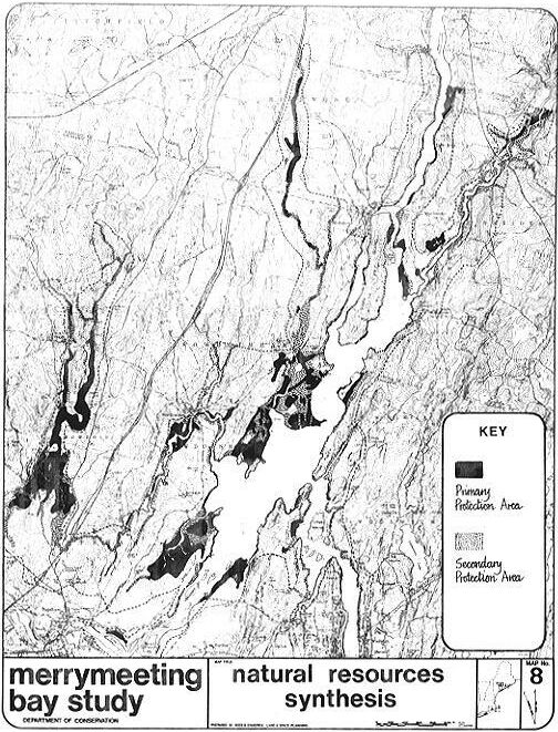