-
Preliminary Permit Application to the Federal Energy Regulatory Commission
(pdf; file size: 469 KB)
Maine Tidal Energy Company (Date: 3/30/06)-
Notice of Application Accepted for Filing with the Federal Energy Regulatory Commission
(word doc; file size: 41 KB)
Notice from FERC that the Maine Tidal Energy Company has filed a preliminary permit and the public comment period has started. (Date: 5/2/06) - Notice from FERC to Maine Tidal Energy acknowledging receipt of permit application:
-
page 1 (letter)
page 2 (list of who was cc'd)
page 3 (list of relevant addresses)
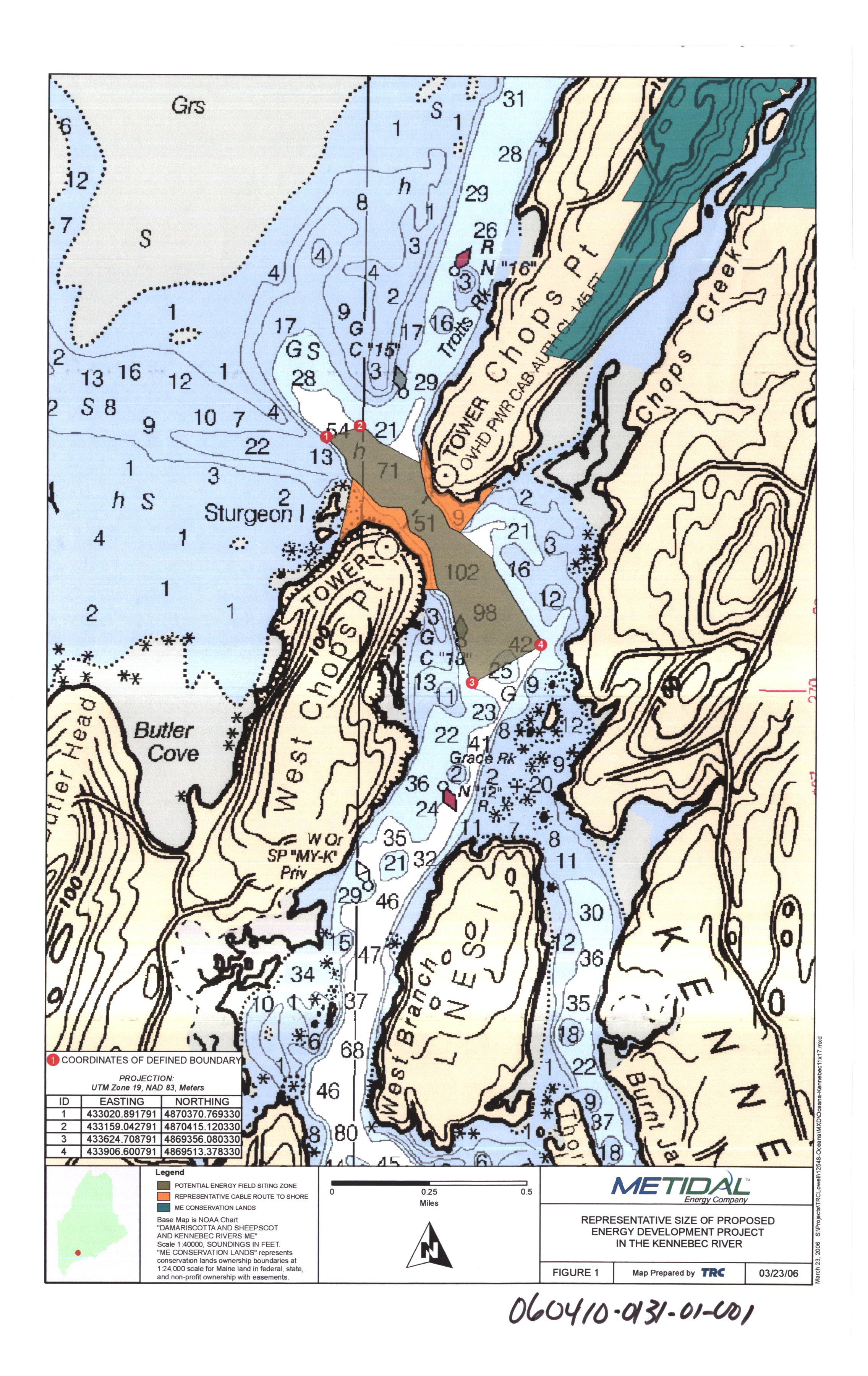
Map depicting "Representative Size of Proposed Energy Development Project" (jpg; file size 4.07 MB)
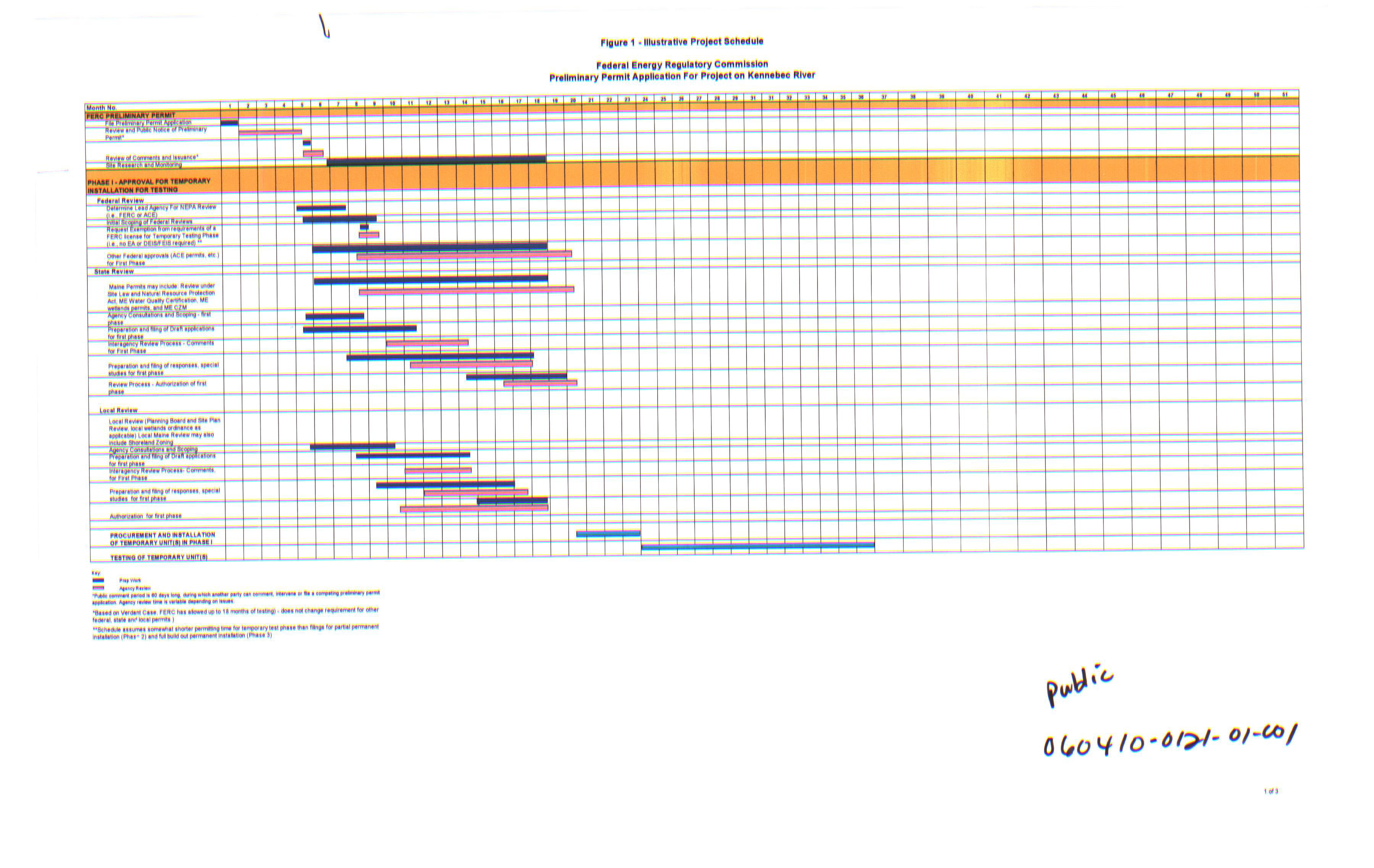
Illustrative Project Schedule: Phase I (Approval for Temporary Installation for Testing) (jpg; file size 2.48 MB)
Illustrative Project Schedule: Phase II (Approval for Permanent Installation of Partial Buildout) (jpg; file size 783 KB)
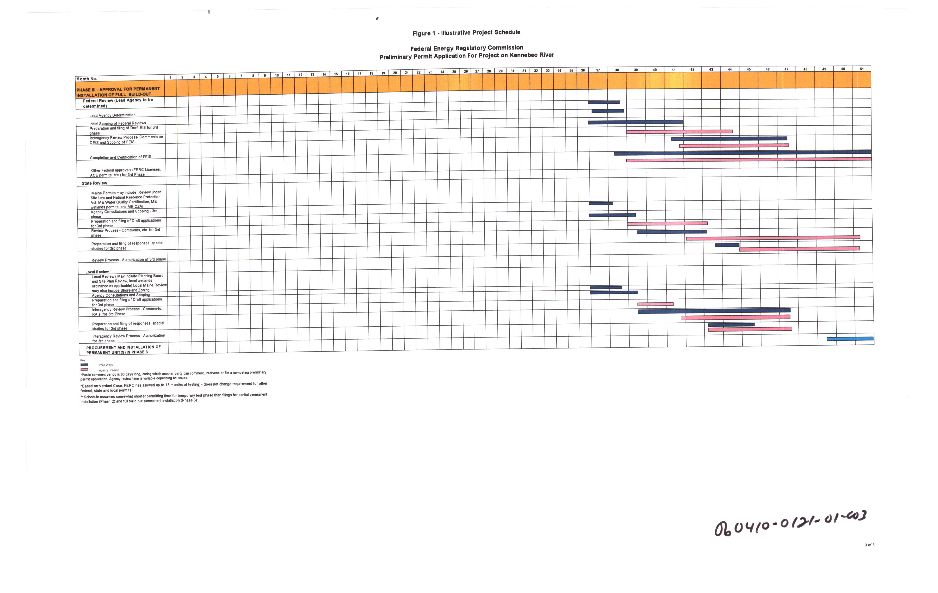
Illustrative Project Schedule: Phase III (Approval for Permanent Installation of Full Buildout) (jpg; file size 1.44 MB)
NOTE: If these charts are illegible, use the zoom tool in your browser
Primary consultants to Maine Tidal Energy: TRC (Consulting firm) and Pillsbury, Winthrop, Shaw, Pittman (Law firm)
Date: 5/9/06
-
Notice of Application Accepted for Filing with the Federal Energy Regulatory Commission
(word doc; file size: 41 KB)
-
Letter from OCEANA to FERC supplying additional information requested by FERC (pdf; file size 1.25 MB)
Date: 7/3/06 - FOMB Request for Intervenor Status
- Letter to FERC requesting intervenor status and outlining reasons for opposition to permit
(pdf)
- Supplement to above letter
Date: 7/2/06 (pdf) -
Exhibit 1: American Eel Distribution and Dam Locations in the Merrymeeting Bay Watershed (Androscoggin and Kennebec River Watersheds) (pdf; file size: 3.40 MB)
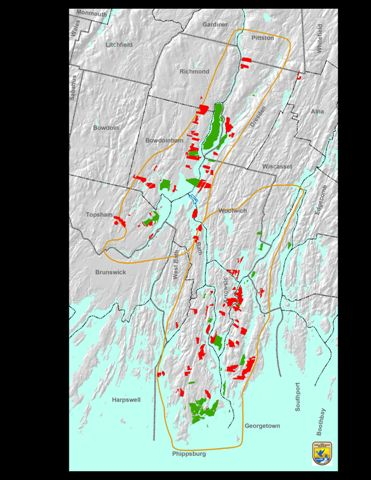
Maps prepared by USFWS, Gulf of Maine Coastal Program (Date: 10/20/05) - Exhibit 2: USFWS Map showing state protected lands in the Merrymeeting Bay/Lower Kennebec area prior to 1995. Chops proposed project area outlined in blue. (jpg)
- Exhibit 3: USFWS Map of current protected lands in the Merrymeeting Bay/Lower Kennebec area. (jpg)
- Exhibit 4: Map of Merrymeeting Bay protected lands in which FOMB had a lead role in protecting (ommitted here for reasons of confidentiality)
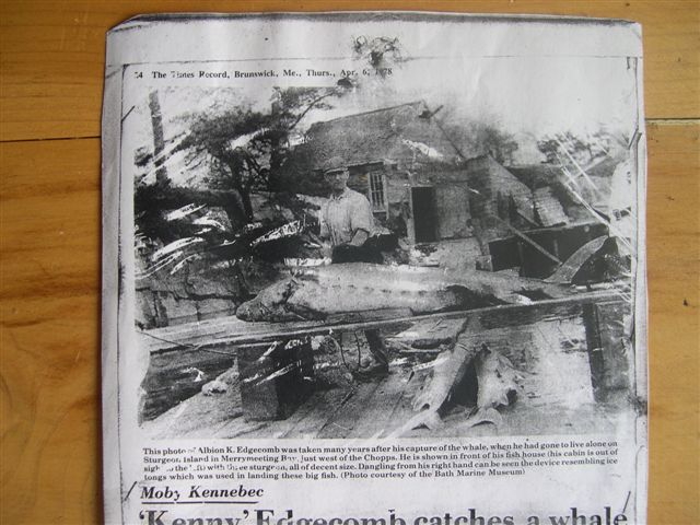
- Exhibit 5: Photo of sturgeon processing on Sturgeon Island early 1900's (Courtesy of Maine Maritime Museum) (jpg)
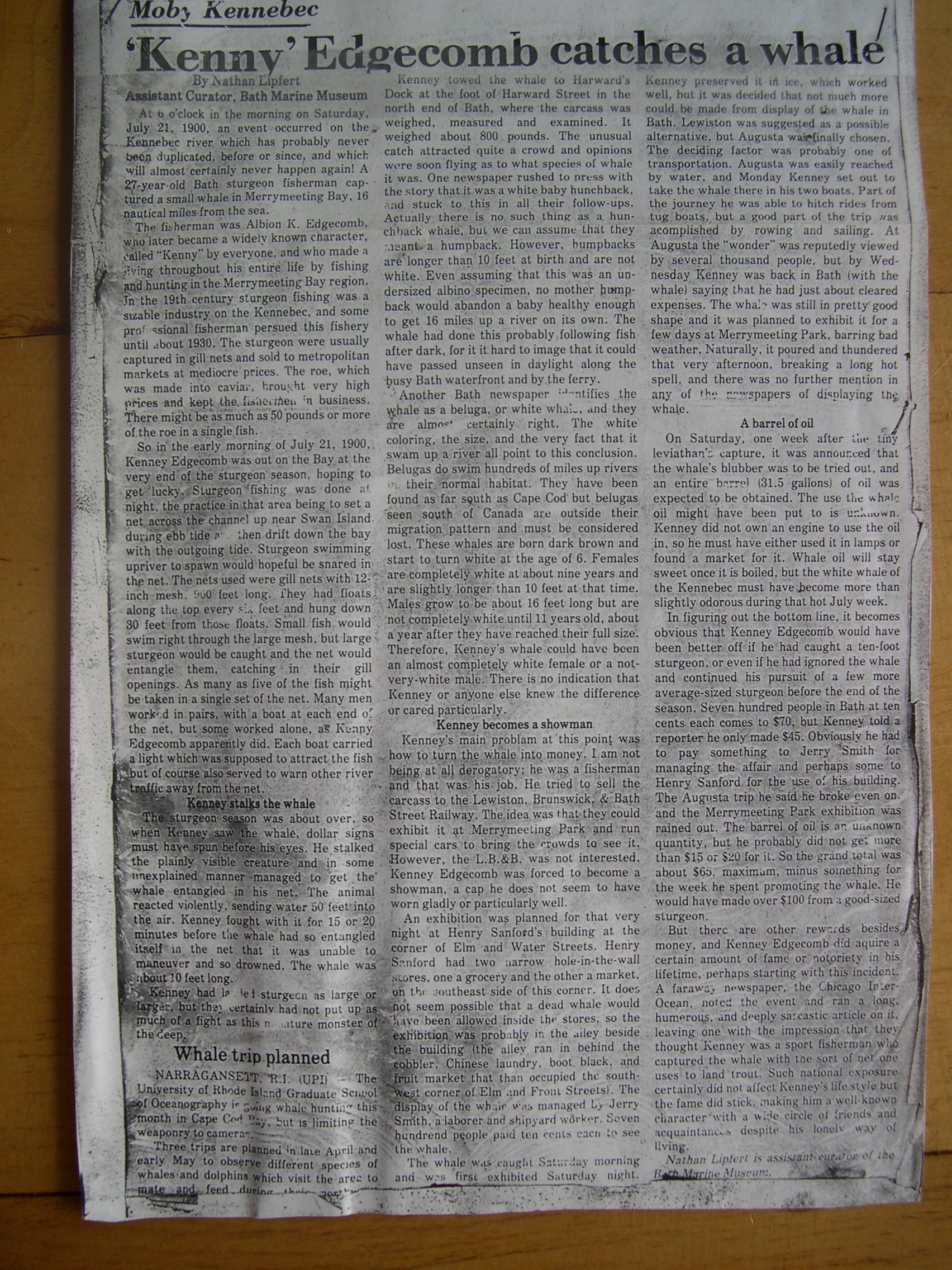
- Exhibit 6: Photo of newspaper article "Kenny Catches a Whale" (The Times Record) (jpg; file size: 2.87 MB)
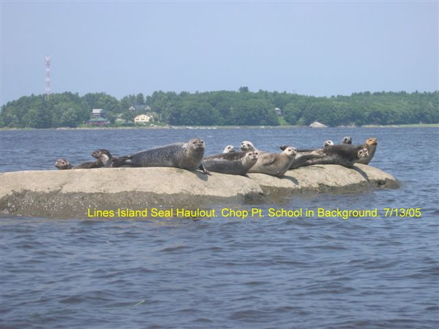
- Exhibit 7: Photo of seals on Lines Island, just below the Chops (7/13/05) (jpg)
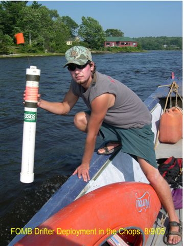
- Exhibit 8: Photo of volunteer, Simon Beirne, deploying drifter for FOMB's current study (8/9/05) (jpg)
- Exhibit 9: Sample Androscoggin drifter track image from April 2006 current study (jpg)
Ed Friedman, Chair of Friends of Merrymeeting Bay (Date: 6/29/06)
- Supplement to above letter
-
FEDERAL ENERGY REGULATORY COMMISSION Maine Tidal Energy Company Project No. 12666-000 ORDER ISSUING PRELIMINARY PERMIT (pdf; file size 77 KB)
Date: 6/24/08 -
FOMB Request for Rehearing on FERC Order Issuing Preliminary Permit for
Maine Tidal Energy Company Project No. 12666-000
(pdf; file size 67 KB)
Date: 7/24/08 -
FERC ORDER GRANTING REHEARING FOR FURTHER CONSIDERATION
(html file; size 5 KB)
Date: 8/25/08 -
Preliminary Permit Progress Report
(pdf file; size 37KB)
Maine Tidal Energy Company's Six-Month Progress Report #1 for the Kennebec Tidal Energy Project under P-12666.
Date: 11/30/08 - Oceana Notice of Kennebec Permit Surrender (pdf file 34 KB>
(due to environmental sensitivity of site)
May 31, 2009 - NOTICE OF SURRENDER OF PRELIMINARY PERMIT (pdf file 13 KB>
FEDERAL ENERGY REGULATORY COMMISSION
June 10, 2009 - Other letters & documents
-
Letter from the
National Marine Fisheries Service to FERC indicating that NMFS wishes to be kept informed
of all developments and may request intervenor status in the future.
- Comments from individuals
Letter from the Maine Historic Preservation Commission to FERC indicating that parts of the Chops fall under regulations of the National Historic Preservation Act, and that an archaeological survey will consequently be required. (Date: 5/19/06)
Letter from the Town of Woolwich to FERC indicating that the town has filed for intervenor status (Date: 6/6/06)
Letter from the Town of Bath to FERC indicating that the town has filed for intervenor status (Date: 6/14/06)
Letter from the US Department of the Interior to FERC indicating that while the DOI does not object to the project, they note that the project uses untested technology and could have "significant adverse impacts on fish and other aquatic resources". (Date: 6/16/06)
Letter from the West Chops Point Homeowners Association to FERC commenting on concerns (Date: 6/25/06)
Letter from the State of Maine to FERC requesting intervenor status (Date: 6/28/06)
Letter from Verdant Power, LLC to FERC requesting intervenor status and protesting the permit (Date: 7/3/06)
Letter from Oceana to FERC requesting dismissal of Verdant's Motion to Intervene (7/17/06)
Letter from George Frampton to FERC opposing Verdant's comments (7/18/06)
Comments from Senator Orrin Hatch to FERC in general support of Oceana's tidal projects on the U.S. coasts (9/18/06)
Letter from FERC to Orrin Hatch providing notice of a FERC-sponsored Technical Conference on tidal energy to be held Dec. 6, 2006 (10/19/06)
- Press Coverage
-
Tidal energy project given preliminary permit
Bob Kalish, Times Record (Date:6/25/08) -
Opposition to tidal project surfaces
Bob Kalish, Times Record (Date: 7/10/06) -
Kennebec tidal flow an energy source?
(with reader comments from FOMB and others)
Dennis Hoey, Portland Press Herald (Date: 7/18/06) -
Tidal energy, fish habitat at odds in debate
(with reader comments from FOMB and others)
Dennis Hoey, Kennebec Journal (Date: 7/24/06) -
Tidal energy project sinks
Seth Koenig, Times Record (Date: 6/3/09) - Energy co. drops project in face of "local hostility"
MAINEBIZ NEWS STAFF (Date: 6/4/09) - Tidal power developer finds 'local hostiles' in the water
Portland Press Herald
John Richardson (6/6/2009) - The Chops: The wrong location for a tidal energy project
Times Record - Opinion
Ed Friedman (6/12/2009) - High tide for alternative energy
Portland Daily Sun
(6/16/2009)
-
Tidal energy project given preliminary permit
-
Electric Power Research Institute Briefing on Ocean Energy
(pdf; file size: 1.37 MB)
Presentation at the International Energy Agency - Ocean Energy Systems
Presenter: Roger Bedard (EPRI); (Date: 11/16/05) -
Maine Tidal In-Stream Energy Conversion (TISEC): Survey and Characterization of Potential
Project Sites
(pdf; file size: 11.3 MB)
Electric Power Research Institute (EPRI) North American Tidal Flow Power Feasibility Demonstration Project
George Hagerman (funded by Maine Technology Initiative); (Date: 4/7/06) -
Tidal Current Energy Technologies
(Word doc; file size: 365 KB)
Ibis (International Journal of Avian Science), Vol. 148, p 145
Peter L. Fraenkel (Date: Mar., 2006)
